National Trust lecture: Ancient and early maps of Sri Lanka
View(s):Prof. Senake Bandaranayake will deliver the 49th lecture in the monthly lecture series of the National Trust- Sri Lanka at the HNB Auditorium, 22nd Floor, HNB Towers, 479 T.B. Jayah Mawatha, Colombo 10 at 6.30 p.m. on Thursday March 28 immediately after the Annual General Meeting which will commence at 6 p.m. The lecture titled ‘Sri Lanka: Ancient and Early Maps (some visual notes)’will be simultaneously transmitted to the E.L. Senanayake Children’s Library Hall at Kotugodella Veediya, Kandy.

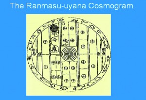
A Sri Lankan map of the universe in the Royal Goldfish Park, Anuradhapura.
In the trajectory of human history, map-making, in the widest sense of the term, is about 10,000 years old. A map is (usually) a cognitive, visual, 2-dimensional statement, or summary, relating to one or more features present in a given territorial (or celestial) space. Its scope could extend from ‘maps’ of the universe, or maps of the world, to a map of the neighbourhood you live in. However, it is only in the last 2000 years or so that the serious mapping of the world, or of particular territories began, and less than 200 years before we could ‘get it right’. It is interesting that Sri Lanka features not insignificantly in this story. This lecture presentation is a sequence of selected images from Prof. Bandaranayake’s notebooks, illustrating some aspects of Sri Lanka’s presence in the history of cartography.
Prof. Senake Bandaranayake, D.Phil. Oxon. is Emeritus Professor of Archaeology, University of Kelaniya and the Postgraduate Institute of Archaeology. He is the author of a number of books and articles. His most recent book is Continuities and Transformations: Studies in Sri Lankan Archaeology and History, published by the Social Scientists’ Association in December 2012.
The lecture is open to members and the public at a nominal fee.
Follow @timesonlinelk
comments powered by Disqus


