Adam’s Bridge:Stepping stone to untapped adventure
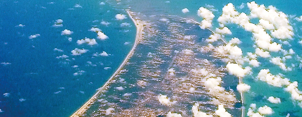
I wanted to visit Adam’s Bridge (or Rama Setu) straddling Talaimannar (on Sri Lanka’s Mannar Island) and Dhanuskody (on India’s Rameswaram/Pamban Island) for a long time. The putative “bridge” is a 30-km long chain of 16 limestone shoals one-half of which belong to Sri Lanka.
Ramayana, the Indian epic, says Rama built this “bridge” with the assistance of Hanuman, the monkey god, to rescue Sita from Ravana, the demon king of Lanka. Mahavamsa identifies Thambapanni, where Prince Vijaya, who became the first Sinhala king, and his retinue of 700 landed in the sixth century BCE, as the Mannar coast. Moreover, Muslims believe that Adam crossed this chain of islands to stand on one leg for 1,000 years on Adam’s Peak (Samanala Kanda) as a penance for his indiscretion in Eden.

Pic courtesy PlaneMad/Wikimedia (http://commons.wikimedia.org/wiki/File:Adams_Bridge_aerial.jpg)
These stories associated with Adam’s Bridge stimulated me to visit the venue. However, I was unable to do so until my 10-day tour of the island, at the age of 73, in early April this year.
We (my spouse and I) hired an air-conditioned car and an experienced driver to take us on an exciting travel adventure of Sri Lanka covering roughly 1,000 km. Our driver, Amal Chandrakumara, proved to be an inexhaustible storehouse of knowledge that enabled us to locate many of our friends and relatives whom we had not met for several decades. We travelled anticlockwise from Colombo to Galle on the Southern Expressway, and then continued on to Weligama, Matara, Hambantota, Yala National Park, Bandarawela, Haputale, Nuwara Eliya, Kandy, Polonnaruwa, Trincomalee, Vauniya, Talaimannar, Anuradhapura, Dambulla, Kurunegala, and Negombo.
Early on the tour, we realized that we had chosen the wrong time of the year for exploring the island. The unbearable heat of the Bak (April) month exhausted us. Fortunately, our air-conditioned vehicle helped to lessen our discomfort. The abrupt transfer of our bodies from extremely cold Minnesota to the tropical heat of Sri Lanka was a bad idea. However, on the positive side, we had the opportunity to celebrate the Aluth Avurudda with family and friends, and to enjoy the benefits of spending less on posh accommodation.
But despite the negatives, we managed to complete our adventure. We reached Mannar (pop. 35,817) on April 7 (Sunday) afternoon straight from Trincomalee—a tedious drive of 154 km crossing the island from the east coast to the west. Just five years ago, this would have been a very risky task because the Tamil Tigers ruled the roost in this land. On this occasion, only stray dogs, cattle, monkeys, and drivers of ubiquitous India-made tuk-tuks (the sputtering motorised rickshaws) and gigantic lorries seemed to pose an immediate threat to our survival on the road.
We reached Talaimannar, another 55 km northwest of Mannar, in the late afternoon. To our dismay, we found the old pier on the northern tip of the Mannar Island occupied by the Sri Lanka Navy. In sheer frustration, we got off our vehicle and walked around the blocked area to the sandy beach and headed toward the rusty crumbling pier where the Navy personnel stopped us.

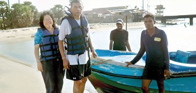
The writer and his wife Yoke-Sim with two navy recruits and the boat that took them to Adam’s Bridge
They called us to their operational quarters on the Thambapanni beach and informed us that they provided a boat service for tourists to explore the islands of the Adam’s Bridge that belonged to Sri Lanka. Because it was late afternoon on a Sunday, they would charge us Rs. 3,600 ($ 29) for a boat ride to the No. 2 island on the “bridge,” even though we had only three passengers, including the driver. Normally, the fee per passenger was Rs. 600 as the receipts they gave us indicated.
Having come half-way round the world, we were in no position to argue with the Sri Lanka Navy and miss the only chance we had to land on Adam’s Bridge. We agreed. Two pleasant Navy recruits helped us to put on the required life jackets and get us onto the small boat. They steered us all the way to the No. 2 island through the rough waves—a literally bumpy ride that caused pain to our posteriors and splashed water on whatever we wore. And it was indeed a relief when they let us off on the barren shoal, 15 km away from the old pier, with only a single hut in the vicinity so we could enjoy the sandbanks and chase after the seagulls. For me, they all looked like the flock of Jonathan Livingstone Seagull, the protagonist of Richard Bach’s novel published in 1970.
The vicinity of Adam’s Bridge is also known for its population of dugongs, who feed on 120 varieties of sea grass inherent to the region. But not a single dugong came to our view during the tour. In less than one hour we were back at the old pier somewhat disillusioned but not altogether disappointed with our view of Adam’s Bridge.
The Navy’s boat service to the “bridge” commenced in April 2011. Yet the Navy has not succeeded in elevating it to world-class level. I couldn’t find any literature promoting the facility. Perhaps the Air Force could initiate a helicopter service to view the chain of shoals. Establishing a modern visitors’ centre a la American style in cooperation with Tamil Nadu would be a good beginning.Talaimannar was the terminus of an Indo-Lanka ferry service to Rameswaram/Pamban Island as part of the Medawachchiya-Dhanuskodi railway line until December 1964 when a severe cyclone destroyed the Talaimannar Railway Station that served the pier. Now, with the end of the Tamil Tiger uprising, efforts are afoot to restore the abandoned Medawachchiya railway track.
After we left Talaimannar, we stopped in Mannar again to see the famous Baobab tree planted by Arab traders in 1477. The tree is shaped like a giant ball with a 19-metre circumference. It is, therefore, evident that Arabs preceded Columbus in geographical exploration.

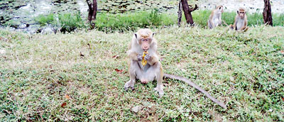
Monkeys on the road from Trincomaleeto Mannar. Pic by Yoke-Sim Gunaratne
Mannar is also well known for its fort, which the Portuguese built in 1560. The Dutch rebuilt it in 1658, but today its interior is pathetically run down.
Because this predominantly Tamil area still lacked adequate tourist facilities, our driver took us to a comfortable hotel in Anuradhapura, more than 93 km to the southeast of Mannar, to spend the night.
Because we were so tired, we forgot to look to our right to catch glimpses of the northeastern boundary of the Wilpattu National Park, which we were passing.
The writer is the author of From Village Boy to Global Citizen (Vol. 2): The Travels of a Journalist (Bloomington, IN: Xlibris).
Follow @timesonlinelk


