|
Old Dutch map sheds light on Kotte's
past
By Dr. K. D. Paranavitana
The capital of the kingdom of Kotte,
Sri Jayawardhanapura or the 'City of Victory' emerged
due to the strenuous efforts of Nissanka Alakeshvara
(1340-80). It reached its zenith of prosperity during
the reign of King Parakramabahu VI (1411-66) whose rule
has been eloquently described by historians and sung
by poets of the time.
Kotte as the capital city ceased to
exist from 1565 when it was abandoned with the removal
of nominal ruler Don Juan Dharmapala to Colombo by the
Portuguese. The city was virtually razed to the ground
by the Portuguese in the latter part of the 16th century.
Hardly any original structure of the city is left standing
at present for us to see. The grandeur of the palace
and temples which existed in the halcyon days of King
Sri Parakramabahu VI could be imagined only from the
writings of courtiers and poets.
 |
| Elias’s map of Kotte |
The citizens of Kotte struck with
dismay at the ruthless destruction of their noble edifices
and sacred temples escaped to villages in neighbouring
districts fearing for their lives. Kotte perished and
the neglected lands and heaps of ruins were gradually
covered with wilderness. During the Dutch period it
became merely a village accounted for revenue purposes.
"It is both strange and unfortunate,"
writes H.C.P. Bell in his Annual Report of 1909, "that
among the fairly numerous plans of the chief towns of
Ceylon left by Portuguese and Dutch writers, not one
of Kotte has come to light." Researching the subject
at the National Archives of the Netherlands in The Hague
this writer was, however, able to trace an interesting
location map of Kotte which seems to have been copied
by land surveyor Pieter Elias circa 1790.
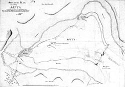
The legend on the map states, "the
situation plan of the village Kotte located one and
a half hours distance from Colombo. The exact situation
of Kotte together with surrounding villages with fruit
and wild trees grown in rough and uneven manner. - P.
Elias".
Elias in his map indicates the exact
situation of the citadel, its surrounding villages like
Battaramulla to the east and Nawala to the west and
on the north and south west with fortifications and
a gateway. A road led right across the village starting
from the direction of Colombo and continued towards
Galkissa and further to Salpiti Korale. Passing the
gateway on the side of Colombo was a toll and rest house.
The village shows only the important
buildings such as the site of the palace, warehouse
of the company, a school and a dried tank. Close to
the entrance on Etul Kotte, a cinnamon plantation is
shown. Elias, however, has not indicated the ancient
ruins and the places of worship merely because such
places were considered of heathen interest and of no
economic value. The layout of the citadel that existed
during the heyday of the kingdom was preserved at the
time Elias made this map.
The places shown on the map are as
follows:
1. The Village Battaramulla
2. A section of Pita Kotte
3. Village Kotte
4. Village Navala
5. Paddy fields which ultimately join Kelani River at
Nagalagam pass
6. Cinnamon Gardens
7. Seat of Government -King's Palace
8. Dried Tank
9. Warehouse of the Company
10. Gravet and the Rest House
11. The meeting place of two tributaries
12. The road to Galkissa and further towards Salpiti
Korale
The descriptions of Kotte embodied
in the Nikaya Sangrahaya and in the Diogo de Couto's
(1543-1616) The History of Ceylon tally with this map.
Elias naturally had paid special attention to taxable
lands of Kotte and places of interest to the company.
What is lacking in the map is information on Buddhist
places of worship and details of ruins.
It may be of some interest to the
reader that contents of this map be studied in relation
to the Dutch tombos compiled for the purpose of collecting
taxes for the company during the period 1755-76. The
Portuguese were succeeded by the more ordered administration
by the Dutch. At the beginning of Dutch rule in 1656,
Kotte was still a ruined city covered with shrubs. Certain
early Dutch maps indicated Kotte as 'Ruins of the Palace
of Cota'. It was somewhat later the Dutch set about
to restore the dues from Etul and Pita Kotte and particulars
duly taken into the tax registers called tombos. Unlike
the Portuguese, the Dutch went into more detailed and
exhaustive recording of information on lands and their
owners, classified into two categories -- one for the
names of the land holders and the other for their gardens
and paddy fields called, head and land tombo respectively.
The lands in Etul Kotte and Pita Kotte are registered
under the Palle Pattuwa of Salpiti Korale distinguishing
the two divisions, citadel and their outskirts.
The Dutch tombos reveal some fascinating
information in relation to demography and social mobility
in the early days of the Dutch administration and even
before. Some families abandoned Kotte in Portuguese
times and lived in exile in districts such as Walallawiti,
Pasdun and Hewagam Korales where tranquillity prevailed.
When normalcy was restored, these families returned
and occupied their former holdings. The tombo of Etul
Kotte compiled in 1765 records 41 families and in its
revision made in 1765 the numbers increased to 62 with
34 occupying Pita Kotte. Their land holdings were recorded
in tombo after on-the-spot investigations by the tombo
commissioners.
The ge-names or wasagamas recorded
in the tombo indicate several interesting factors. Ge-names
such as Bulatsinhalage, Welmillege, Pelenda Pathirage,
Nugegodage, Waduwage, Butgamage, Nawalage, Kalubowila
Vidanelage and Wellabaddege have no relevance to Kotte
itself. In the presence of tombo commissioners these
families identified themselves with the name of the
village in which they lived in exile. They returned
to Kotte and re-occupied their former family land holdings.
According to the land tombo of Etul
Kotte, some resettled householders obtained certificates
of letters of authority from the Dutch official in charge
of the district long before the compilation of tombo
in 1765. These documents have been of immense use for
them to substantiate their claims to the land holdings
which were usually recorded in nota bene. These ge-names
are also acceptable evidence to suggest that these families
fled to districts far away from Kotte including Walallawiti
and Pasdun korales, Welmillage, Bulatsinhalage and Pelenda
Patirages. Most of the families that fled belonged to
the govi caste who were either in the military (Hewa/Aratchi)
and civil official class (Nilame/Lienege). When they
re-established in Kotte, service castes were also reintroduced.
They were given less prominence in the list of land
holders. Names of those who did not possess lands are
recorded with a separate entry Heeft geen bezittingh.
(has no land holding).
Another interesting factor is the
naming of lands with names of ancient buildings constructed
on the particular land. Moehandirange Willem Rodrigo,
a schoolmaster of Govi caste owned a land called Pasmalpajewatte
(Garden of five-storied palace, a family inherited land).
Colombe Tantrige Laurens Perera who lived in the vicinity
owned Pasmalpaje Werehe Kongahawatta (Garden of five
storied temple, Kongahawatta). This resembles the garden
on which the temple residence of the great poet Ven.
Sri Rahula who gave us a fascinating record of the glory
of Kotte in his poem Salalihini Sandesaya was.
Certain lands were named Parangiawatta
(Garden of the Portuguese). Pelenda Patirage Mighiel
Dias owned a land in Etul Kotte called Adriaen Ponsoeparangiawatte
(Garden of the Portuguese named Ponsoe) and at the time
of the tombo registration, the name changed to Telemboeghawatte.
Pattijege Christoboe Silva was in possession of a land
named Kitoelgodde Parangiawatte (Garden of the Portuguese
of Kitulgoda).
Those registered land holders of Etul
and Pitakotte never changed the Portuguese ‘cognomen’
given by their ancestors. The Dutch also never issued
proclamations prohibiting the use of Portuguese names.
Some of the names are as follows: Soeseuw de Almedage
Francisco Perera, Gasparoege Siman de Coste, Don Anthonyge
Don Joan and Don Constantino Madere de Basto.
One of the most prominent families
of Kotte was the Magellege family which inherited paraveni
lands situated near the palace and the Dalada Maligava
of Etul Kotte. Therefore, this family received a foremost
rank in the list of names recorded in the tombo. The
Magellege family owned a land holding referred to as
Maligawatta or the 'Garden of the palace' with adjacent
land called Gabadawatta, or the 'Garden of Treasury'.
It is said, the family escaped Kotte
fearing of the wrath the invader, retired to more remote
villages situated far away in Walallawiti and Pasdun
Korales where the Portuguese terror did not exist and
returned when Kotte was brought back to normalcy. At
the time of compilation of tombo Magallege family confirmed
their right of ownership of their land holdings with
documents.
The maps and tombo when combined can
extract good results in respect of the social mobility
and demographic pattern that existed in colonial Sri
Lanka in the 16th and 17th centuries. It also shows
a remarkable growth of re-occupation of the village
Kotte at the end of the Dutch period.
|
