|
Across
the river the elephants came!
By Cecil Dharmasena
The three of us lay huddled under
the large Kumbuk tree while the Mahaweli waters gently
flowed just below us. The trumpeting and roaring came
from both sides and all we had by way of consolation
was just one lantern that cast a sooty glow at the base
of the tree, under which we had spread our ground sheet.
Two lines of elephants were crossing the wide Mahaweli
on either side of us.
It was about nine o’clock and
we had unknowingly selected this spot near the confluence
of the Mahaweli ganga and Amban ganga for a night’s
rest and had just finished a scrap dinner when the commotion
began. It seemed like all the elephants in Sri Lanka
had decided on an elephantine rendezvous across the
river that night.
 |
| North of Manampitiya, the Mahaweli
broadens out into a wide course, constantly overflowing
its bare banks during the monsoons. |
Just before dawn, we heard the splashing
once again. The herds were returning but seemed more
subdued this time. We only heard the splashing and squelch
of mud as they waded out and then a few grunts as they
pushed their massive torsos up the embankment and into
the forest. There being no moon, we could see nothing
which made it doubly terrifying.
This region is the flood plains of
the Mahaweli which extends upto Trincomalee Koddiyar
bay and when we drove through the area the previous
day, we had observed a large number of tobacco growers
lining the river. Today, this whole region comes under
the Flood Plains National Park and the tobacco growers
are, thankfully, gone.
The flood plains starts from about
here where the ancient village of Yakkure lies and extends
northwards along both sides of the river. It is a unique
land of ancient history, of marshy plains, of the extraordinary
“wilas’ or “villus” and the
home of the giant swamp elephant.
Yakkure was then a tiny village, a
hamlet steeped in history, lying along the river south
of Manampitiya. A muddy jungle track would take us there
and to the adjoining beautiful Handapan wila, the first
of the large wilas of the Mahaweli flood plains. These
wilas are huge basin like depressions on an otherwise
flat landscape which fills up with water when the river
floods over during the rains. During these floods, the
entire region north of Yakkure becomes a vast extended
lake, hence the term “flood plain”. Most
of these wilas or villus are connected to the river
through some sort of channel.
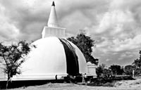 |
| The newly reconstructed Somawathiya
Chaitiya was just a mound of broken bricks in the
jungle when we found it about 40 years ago |
The wilas are unique water bodies, rich in plant life
and in biodiversity. They harbour a high biomass per
unit area. The Mahaweli which broadens out from about
Kalinga Nuwara, a large island with ancient ruins, follows
a convoluted course northwards with a network of branches
and channels. Along this ancient winding course, a series
of dagobas had been built by our Kings of yore, the
most famous one today being the Somawathiya chitiya.
Exploring this fascinating area on
foot many decades ago, we discovered smaller stupas
which lay in ruins deep within the forest. They were
barely recognizable mounds of brick. The river had altered
course at some point in time (due to earthquakes, according
to some geologists) after the dagobas had been built.
Today, only a few of these lie along the present course
of the river whereas the original course would have
been on the western side of the line of dagobas built
on the Ruhuna kingdom (eastern) side of the Mahaweli.
There are around 40 wilas, some of
which like Handapan wila, Bendiya wila, Somawathiya
wila (or Meen villu), Koyamala wila, Trikonamadu villu,
Kompanachchi villu and so on are quite large, being
several miles in circumference. Some have interesting
names such as Gengalawila, Karapola wila, Velvette villu,
Kombu villu etc.
This is the habitat of the Marsh Elephants
or “Vil-Aliya”, a huge tuskless subspecies
as classified by former Director of National Museums,
Dr. P.E.P. Deraniyagala as Elephas maximus maximus vialiya.
One early morning, we decided to visit
the Somawathiya chaitiya, which at that time lay in
ruins in the jungle across the river some miles away.
Walking down from the cattle farm, we crossed the fairly
narrow but deep Kandakaduwa-ela in a rather frail looking
dugout canoe designed for two persons. It sank to its
brim due to the combined weight of eight of us. There
were said to be many riverine crocodiles in the murky
waters of this ela and we would have been easy meat
if any one of them decided on an early breakfast.
Carefully alighting on the muddy opposite
bank, we had to walk about a mile to the Mahaweli through
marshy land. Small mounds of earth cover this wet area
on which tussocks of villu grasses grow. These earth
mounds are the handiwork of numerous earthworms which
build these with their casts so as to catch some air
in the usually submerged ground. It was heavy going
in the mud but eventually we found ourselves by the
broad Mahaweli running directly north on an extensively
broad and flat landscape. Incidentally, the Mavil-aru
which came into prominence recently, is the Mahaweli-oya,
an extension of the Kandakaduwa-ela.
Another decrepit looking dug-out canoe
used by cattle herders was lying drawn up on a sand
bank and having gingerly scrambled in, we pushed off
for the far side. This ride was equally hazardous and
took longer, but thankfully, the water was clear and
shallow. Dimbulagala rock or “Gunner’s Quoin”
rose up from the far horizon, a lonely misty blue sentinel
in the distant south. Unlike in the upper regions, the
river banks were bereft of trees. Tall villu grasses
lined the river and the eroded embankments indicated
constant decrement of soil during flood time. This has
led to a broadening of the river over the centuries.
This is in stark contrast to the upper reaches where
kumbuk and other trees line the banks with their masses
of roots forming a protective net that effectively prevent
erosion. Numerous muddy slides on each bank indicated
the constant intrusion of herds of elephants that use
these points to cross the river.
After almost an hour of hard paddling
against the cross current, we were across and having
carefully deposited our crude conveyance on high ground
(we did not want it washed away) we marched in single
file onto the vast Somawathiya wila. Since the wila
had some water we had to take a circuitious route and
in any case, it was more comfortable walking around
the edge of the wila under the shade of the large trees.
The sun was up now and it beat down upon us from a cloudless
blue sky and the going was hot and sweaty. We had totally
forgotten to bring any water or food, but being young
and adventurous then, this lapse did not worry us overmuch.
In the distance, we espied “Eric
Swan rock” which we soon reached. This long, low,
prominent extrusion of granite on an otherwise flat
landscape, had an unfortunate history. Eric Swan was
one of our best known wildlife photographers at the
time and in September 1957, he and his party including
famous film cameraman Willie Blake, came here to film
marsh elephants. Game Ranger Stanley Silva had also
joined the group. While filming a large cow elephant
just below this rock, they had moved upto 15 yards for
close ups. Suddenly, the animal scented the group and
had charged, knocking down Swan while Blake and Silva
managed to jump clear. Swan died before reaching their
camp. It is said that the rest of the group on the rock
had witnessed this gruesome scene. It was headline news
at the time.
Passing the rock which also carries
some archaelogical inscriptions on the far side, we
walked another mile and then, through the scattered
large trees espied a large mound of bricks, much of
it strewn on the ground around the area. This was Somawathiya
dagoba as we found it almost 40 years ago.
Fallen granite pillars and stone slabs
and a few small, broken Buddha statues, lay all over,
partly buried and undisturbed for two thousand years.
Piles of elephant dung littered the
whole area and we also noticed the flood water mark
that had reached the wall of the “maluwa”
around the stupa. The whole scene looked forlorn, the
jungle tide having taken over a once pristine kingdom,
a place where large ships had docked after sailing up
the Mahaweli and where international trading had taken
place and a massive ship building industry had flourished.
Somawathiya was then a busy trading
post with ship building yards which supplied huge sailing
vessels to the international market. I remember a little
stone pond where a single white lotus bloomed, a thing
of lonesome beauty in this stark landscape. And the
large tree with masses of the Ceylon Grey Orchid in
the recesses of its branches, provided us with some
much needed shade and rest under its cool branches,
while a few painted storks and spoonbills strutted about
in a muddy part of the sunbaked villu.
Some years later, a small bridge had
been constructed across the Sungawila oya and this enabled
us to drive all the way from Polonnaruwa to Somawathiya
where a small temple had been built. The Archaeological
Department had already started excavations and the Dagoba
was being gradually built-up. The lone resident monk
was glad to see us and we decided on staying the night
before moving on.
Today, the whole area is built up
and the chaitiya is a huge white edifice rising into
the blue sky. A broad road through once undisturbed
jungle, takes bus-loads of pilgrims right up to the
chaitiya. It is a far cry from the silence that greeted
us when we sat under that tree full of orchids and watched
a decayed, holy, ancient monument from the distant past
against the backdrop of a cloudless blue sky and a hushed
forest with countless birds circling overhead.
Some decades ago, we decided to drive
through the villu forests north of Trikonamaduwa onto
Trincomalee. Hardly anyone had been through before but
some of the farm labourers insisted there was a jeepable
track to Verugal. Starting off from Trikonamaduwa with
my family and a few friends after an early breakfast,
we soon found ourselves lost in the jungle. There were
numerous cattle tracks and timber trails leading to
dead ends.
Finally we saw a cattle “wadiya’
and the cattle herders were most helpful, detailing
out the road we should take. On the way, we managed
to follow a small tractor with some wood cutters who
pointed out the way to Verugal anicut. From there, the
main road from Batticaloa to Trinco was reached without
difficulty. It was one of the most interesting unchartered
jungle trips I had undertaken with enough thrills for
the children in the party.
Later, the first of the ferries, Kiliveddi,
was crossed without mishap and at the next (Mutur),
we were accompanied by a large herd of goats which surrounded
our jeep on the ferry boat. The next, the Ganga ferry,
is at the main exit of the Mahaweli into Koddiyar bay.
The water here flows deep and fast.
The last ferry before Trinco is Kinniya
and this is a broad and deep crossing with the deep
blue water of the Koddiyar bay rushing into the Tampalagama
bay. A very interesting drive through Sampur brought
us to the Foul Point lighthouse. Although I have nostalgically
yearned to make that exciting expedition once again,
it never materialized and probably never will.
Today, Trikonamaduwa, Verugal, Mawil-aru
( a branch of the Kandakadu-ela which we crossed by
canoe 40 years ago), Sampur, Foul Point and all those
ferries are battle scarred areas and I am thankful I
was able to traverse these fascinatingly beautiful spots
in those peaceful days. Sadly, all those nostalgic thoughts
must remain just memories, deeply cherished ones, at
the back of my consciousness.
(The writer is Former Director, Mahaweli
Environment & Forestry)
|
