|
|
||||||
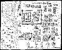
Spilbergen’s map – corrected With reference to the article ‘Nine kings lived here’ published in the Plus last Sunday, I wish to reproduce my research findings that appeared in “The palace of the King Vimala Dharma Siri” from the book 400 Years of Dutch-Sri Lanka Relations 1602-2002 This map of Spilbergen has a classical cartographic error, in that it is a mirror-reversed map of Kandy, as is clearly noted by the fact that the river is on the eastern side, as opposed to it being on the western side of the city. However, the information it provides us is of utmost importance, when it is corrected of this basic cartographic error.
The text provides us with the location and names of the key places of interest, namely, the King’s Palace, the Temple of the Tooth, the Kataragama Devale, the Assembly Hall within the inner fortress, as well as the location and identification of the Maha Vishnu Devale, the Natha Devale and the Pattini Devale, the Guest House – all of which are of archaeological and historical importance. It also indicates the traditional welcome procession afforded to Spilbergen. This map of Spilbergen is contained in the description of his voyages. It is suggested that this map could not be an original map produced by him, but that this classical cartographic reproduction blunder has been committed in the copying process. It is clear that this is from a Portuguese source, because only the Portuguese had access to Kandy, and in fact it was the Portuguese captives that helped build these fortifications for Vimala Dharma Suriya I, and thus they would have had access to the plans of the inner and outer fortress. Moreover, there are similar reproductions by the French, one by Abbe Le Grande in 1701 titled “Plan de Ville et du Chateau de Kandi, Capitale de Isle de Ceylon” or the “Plan of the Villa and Palace of the King of Kandy, the Capital in the Island of Ceylon”, which is reproduced here as Map 7, and below it is indicated the corrected map of Spilbergen, indicated as Map 8.
Further, using the locations of the Kataragama Devale, the Maha Vishnu Devale and the Natha Devale, the writer was able to scale this map to the placements of these Devales, as they are yet in their positions, though the King’s Palace and the Temple of the Tooth were destroyed in 1765 in the time of the Dutch Governor Van Eck. It is based on this that it was possible to produce Map 9 together with the fortifications. The writer was fortunate in 1996 to determine the spread of the Bogambara lake on the basis of field work conducted, when the new Kandy road was under construction. When a section of the old Bogambara wewa was exposed with a peat layer, it became possible, with further soil borings, to examine the topmost peat level and get at the level of this reservoir. The site of the Catholic Church that existed from 1699 to 1745 has also been incorporated to this map, and its location has been indicated based on first hand descriptions of its location at that time. Further, the writer has reconstructed the map of the King Vimala Dharma Suriya I’s Palace complex within the inner fortress, which is indicated in Map 10 in greater detail. The remains of the eastern section of the outer fortress that yet exist are at the new Palace at the north of the Kandy lake built in 1813, and the Guest House lies at the centre of the Kandy lake of today.
While the King’s New Palace and the Temple of the Tooth was built in 1765, east of the old Eastern Rampart was used for only 50 years before the British take over in 1815. This map of the new King Kirthi Sri Rajasinghe’s Palace of 1765 is in the Hague General State Archives, inventory No. 337, which I have examined. Facts are stubborn and comments are free. These are all of archaeological and historical significance, and their locations were identified, because of Spilbergen’s map of Kandy, which provided not only their locations, but descriptions as well. This map is significant, as it provided us with the early environment of the renowned City of Kandy, in the early period of the 17th century. The writer is a Fellow of the National Academy of Science
|
||||||
Copyright © 2006 Wijeya Newspapers
Ltd. All rights reserved. |