
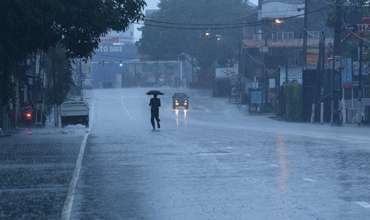
The low-level atmospheric disturbance over the southwest Bay of Bengal and Sri Lanka has intensified into a low-pressure area by today morning (November 25). It is likely to intensify further during the next 24 hours, the Met Department stated.
For Land area:
Due to the influence of this system, the prevailing rainy conditions in the island are expected to continue for the next few days.
Heavy falls above 100 mm are likely at some places in Eastern, Central, Sabaragamuwa, Uva, Southern provinces and in Polonnaruwa district. Fairly heavy falls above 75 mm are likely at some places in the other areas of the island.
For Sea Area:
The sea areas off the coasts extending from Pottuvil to Colombo via Batticaloa, Trincomalee, Kankasanthurai, Mannar and Puttalam will be rough at times as the wind speed can be increased up to 60 kmph. Other sea areas can be fairly rough at times as the wind speed can increase up to 50 kmph at times.
Showers or thundershowers will occur in the sea areas around the island, with very heavy showers or thundershowers likely at some places.
The Met Department requests general public to be vigilant regarding impending extreme weather situation from November 25 to November 29.
For emergency assistance contact the local disaster management authorities.
The public is requested to be attentive about future advisories issued by the Department of Meteorology in this regard.


Leave Comments