- Last Update 2026-04-05 08:03:00

Met Dept issues Red Alert over deep depression in Bay of Bengal
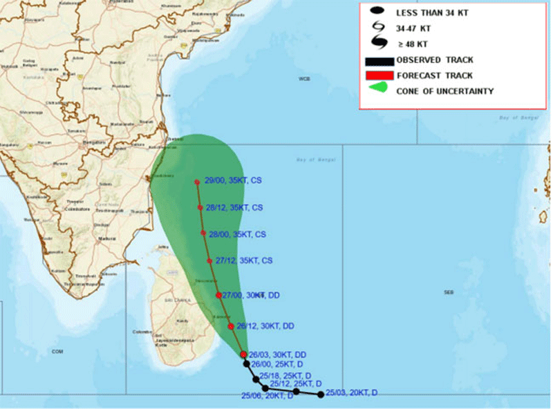
The Met Department has issued a 'Red' alert warning that the depression over the southwest Bay of Bengal has intensified into a deep depression.
The system was located to southeast about 170km of Batticaloa and 240 km of Trincomalee at around 11:00am today (26) and it is likely to move closer to the east coast of the island and intensify further into a cyclonic storm by tomorrow (27).
Under influence of the system, cloudy skies will prevailed over most parts of the island. Very heavy showers and strong gusty winds can be expected in Northern, Northcentral, Eastern, Uva, Northwestern and Central provinces, the Department said.
Showers or thundershowers will occur at times in most places of the island. Very heavy showers above 200 mm are likely at some places in Northern, North-central, Eastern, Central, Uva and Southern provinces and in Puttalam district.
Heavy showers above 100 mm are likely at several places elsewhere of the island.
In its advisory for sea areas, the Department said the deep and shallow sea areas around the island will be rough to very rough, with wind speeds up to 60-70 kmph at times. Very heavy showers or thundershowers are likely at some places areas around the island.
The swell waves, about 2.5–3.0 m height (this is not for land area) may increase in the sea areas off the coast extending from Batticaloa to Kankasanthurai via Trincomalee. There is a possibility that near shore sea areas off the coast extending from Batticaloa to Kankasanthurai via Trincomalee may experience surges due to swell waves.
The Met Department warned naval and fishing communities not to venture to the deep and shallow sea areas around the island until further notice.They are also requested to be attentive about future advisories issued by the Department of Meteorology in this regard.
The Department requested the general public to be vigilant regarding the impending extreme weather situation from November 26 to 27.
The public is also requested to contact local disaster management authorities for emergency assistance and to be attentive about future advisories issued by the Department of Meteorology in this regard.
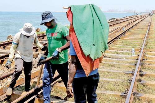
Heavy rainfall has caused significant disruptions across various mountain routes as well. Landslides along the Badulla-Bandarawela railway line and on major routes including Bandarawela-Haputale and Yahalbedda, have resulted in delays and blockages.
In Haputale, a landslide damaged a building near the post office, while several other landslides in the region have caused significant challenges for local residents.
In response, the Sri Lanka Navy has deployed relief teams to the Akuressa and Athuraliya areas in the Matara district, which are experiencing severe weather.
Due to the Nilwala River’s overflow, relief teams are assisting flood-affected areas and facilitating transport for communities in flood-prone regions, including Athuraliya, Balakawala, and Arampathwala.
Cloudy skies are expected to prevail across much of the island, with heavy showers and strong winds forecasted for the Northern, Eastern, Uva, and Central provinces.
Frequent showers and thundershowers are expected throughout the island, with heavy rainfall exceeding 150 mm likely in parts of the Northern, North-central, Central, and North-western provinces, as well as in the Trincomalee district tomorrow. In addition, several areas may receive heavy showers of around 100 mm.
Strong winds, reaching speeds of 40-50 km/h, are also expected at times over the Northern, North-central, Central, North-western, and Eastern provinces, as well as the Hambantota district.
In light of these conditions, the Navy has ensured safe transportation for students sitting the GCE Advanced Level exams. A total of 134 relief teams remain on standby for further assistance.

-
Still No Comments Posted.


- April 2, 2026 - 198 - 0
Water cuts commence from today in Colombo district
The National Water Supply and Drainage Board (NWSDB) warned that water supply restrictions would be imposed from 8.00pm today in Colombo District from today onwards
- March 27, 2026 - 157 - 0
Temperature set to increase to ‘Caution level’
The meteorology department issuing a warm weather advisory for today that the temperature felt on human body is likely to increase up to ‘Caution level’ at some places in Western, Sabaragamuwa, Southern, North-western, Northern and North central provinces and in Monaragala district.


Related Articles

Health fears as substandard coal doubles fly ash, Mercury levels
- 05/04/2026 - 28 - 0

VAT on foreign digital services postponed again
- 05/04/2026 - 23 - 0

LCC tightens rules, floats tender for 2.28mn MT of coal for 2026–27 season
- 05/04/2026 - 22 - 0

China offers fuel to Sri Lanka; shipment due within weeks
- 05/04/2026 - 35 - 0
Leave Comments