
Satellites taking accurate pictures of the earth have been around since 1972 when the LandSat1 satellite was launched. Satellite Technology has been used by big governments, but now thanks to the rapid advancements in technology Maxar’s Worldview Satellite Technology gives any company or research academic the best project management and sustainability tools to manage today's rapidly changing landscapes - whether it be in infrastructure development, agriculture, or even finance.
Combined with existing ground services, high resolution satellite imagery provides broad spectrum ranges that the naked eye is unable to measure. Therefore satellite information can help with pinpoint accuracy (a) Infrastructure design such as roads and townships and (b) even provide abirds eye view of the health of vegetation in large commercial agricultural lands. Especially if we continue to use organic fertilisers, having a macro snapshot of the health of commercial farms becomes very important.
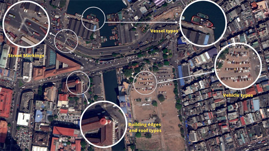
WorldView3/4 with 30cm/15cm resolution can enable you to see details such as the roof types and shapes of individual homes - (for potential rooftop solar projects). Also the types, colors and shapes of vehicles and infrastructures such as power lines, light poles, etc - (for road project tracing and mapping).
When your project decisions require you to accurately identify features on the ground, satellite imagery provides the best visual experience.
The Maxar15cm HD imagery is the best visual experience commercially available on the market today for accurately feature identification and detailed mapping.
HD - Commonly referred to as “High Definition” in most commercial products such as our TV sets - has a similar meaning with Satellite images. Maxar have their own unique proprietary HD image technology that greatly improves the visual clarity of an image. The image is aesthetically refined with precise edges and well-reconstructed details.
Almost all large scale western world projects and products use Maxar HD or other HD imagery. Use-cases in industries such as automotive, civil government, industry, technology, defense, are exhaustive. Below are some examples.
There are many other applications that can benefit from improved precision of AI/ML information extraction, feature extraction, and enhanced clarity provided by HD satellite imagery.
In Sri Lanka, the protection of our coastline can be greatly assisted by a suite of Maxar HD satellite imagery and surveillance services that - along with existing fishing vessel tracking systems - would be able to better monitor and police our coastal waters so that illegal fishermen would not be able to exploit our territorial waters as they have done before.
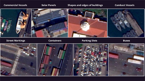
Different types of objects at Colombo Fort become more defined with the help of Maxar’s15cm HD imagery. Image credit: Maxar Technologies
Yes -Satellite imagery can compliment drone imagery. But if your project covers a large area of interest, anything larger than 2 square kilometers, HD satellite imagery is more ideal than drone imagery because its faster, more efficient, cost-competitive, reduces mobilization, risk, and supports collections over hard to fly regions.
Please contact Genesiis Software (Pvt) Ltd., the premier satellite imagery provider in Sri Lanka and the Maldives, for all Maxar (USA) and HEAD (China) satellite imagery products. For more information and queries, please visit www.genesiis.com, www.maxar.com or contact GIS specialist Nishshanka on 0776784883 or email to nishshanka@genesiis.com .


The final rites of veteran broadcaster, writer, and lyricist Nirmala de Alwis will be held today at Peradeniya.

Read this week’s Sunday Times for your interesting articles


Leave Comments