
The Department of Meteorology predicts that due to an atmospheric disturbance over the South-east Bay of Bengal Sea area, the island’s wet weather conditions will intensify today (30).
Occasional showers or thundershowers are most likely in Northern, North-central and Eastern Provinces.
Heavy rainfall over 100mm is possible at certain areas in Northern, Eastern,Central and Uva Provinces.
Besides, multiple places in the remaining provinces will see showers or thundershowers after 1:00 pm, a Duty Meteorologist of the Met. Department said.
The public is urged to take preventives to avoid damage from temporary strong winds and lightning during thunderstorms.
The Met. Department further foresees around November 30, a low-pressure region between the South Andaman Sea and the South-east Bay of Bengal is expected to track west-northwestward, deepen into a depression over the southeast Bay of Bengal, and develop into a cyclonic storm.
Hence, naval and fishing communities were sent word not to venture into deep and shallow sea areas and were further requested to be on alert on future forecasts sent out by the Met. Department.
Showers or thundershowers are on the cards at multiple places in the sea areas surrounding the island.
Winds will strike North-easterly at 30-40 KMPH in the sea zones off shores extending from Chilaw to Trincomalee via Puttalam, Kankesanthurai. Winds will be at 20-30 KMPH in the sea regions off the coast extending from Galle, Hambantota via Matara.
Offshore waters extending from Chilaw to Trincomalee via Puttalam, Kankesanthurai and from Galle to Hambantota via Matara and the rest of the marine areas are expected to tone down although strong gusts of wind and turbulent waters are foreseen during thunderstorms transiently.


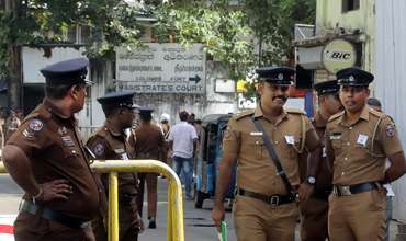
Former President Ranil Wickremesighe was remanded till August 26 by Fort Magistrate Nilupuli Lankapura a short while ago.

Former President Ranil Wickremesinghe was arrested by the CID this afternoon in connection with the misuse of public funds.


Leave Comments