It was the fairyland-like scenery that we had seen from atop Batalegala in our inaugural hike, of a distant water fall gushing down between two rocky ridges that prompted us to hike there one day. That hike made us feel that we should go still beyond to explore the mountain range above the fall.
Thus having reached the top of the waterfall one day, we set out to cover the mountain range beyond the waterfall and reach a place called Rassagala. We were treated to a panoramic view of the scenery around from the top of the waterfall, while in the cool refreshing water.
Later we walked along a footpath on the right bank of the stream till we reached a minor road way and walked on until we reached a village. Here we found an old Ambalama still in a fairly well preserved state, being maintained we were told by the village temple. The existence of the Ambalama here points to a possibility of the old road way to Kandy passing through here in ancient times.
From the village we took an estate road climbing up steadily. While some were walking briskly getting baked in the afternoon sun, others lagging behind suddenly showed up in the back of a lorry. We all went that way to the factory and then walked further up to reach a plateau with a stream flowing by - an ideal location to spend the night.
A few inquisitive youngsters from the estate helped us in finding fire wood and cooking - helping themselves to our limited stock of food and beverages. They also brought some musical instruments to start a singsong before we retired into our tents. With the camp site being close to the summit of the mountain and thereby exposed to the winds from the valley below, the night became extremely cold.
At dawn we could get a bird’s eye view right round. On to our left was Bible Rock in the cross elevation without its familiar Bible-like appearance as one sees from Kadugannawa. A little to the right, we could see the valley of the water stream that formed the Asupini ella and faintly trace our path from there on.
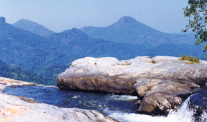 |
| Top of the waterfall with Bible Rock shown with arrow in the background |
Beyond the valley opposite the waterfall we could see Alagalle behind which was seen Handurukkande, the highest peak in the North Western Province. To the right of this was the Hantana range and beyond the Hantana range was seen Knuckles separated by the mist-filled Dumbara valley.
Resuming the hike we entered the jungle at the border of the tea estate and continued the climb to reach the summit of the mountain range. The summit was very narrow. From there we could see the Sri Pada range on one side and Knuckles on the other side confirming that we were at the highest point in the Nawalapitiya region.
Walking to the left from the summit we could go down to the Nawalapitiya side. We headed right from there instead to reach the foot of Rassagala which was a tall rock rising up almost vertically like a tower. Some climbed to the top to enjoy the scenery from up there. After climbing down from the ‘tower’ we continued to move ahead in the same direction and decided on going down from a seemingly suitable site. It was not to be as easy as we thought. Though this route took us down swiftly, it was very steep.
We had to literally slide down the precipice crawling down on all fours facing the surface of the ridge and using our hands to cling on to vegetation on the ridge as we went down. It was a do or die exercise. It was only after safely reaching the base of the ridge, did we realize that the supposed to be footpath, that we had come down had really not been one but a passage used for sending down logs from above.
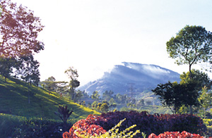 |
| Rassagala as seen from the tea estate |
However after reaching the base of the ridge, we saw a roadway. Feeling hungry after the strenuous descent and being happy that we had finally reached some kind of road we got down to cooking a meal, not rice and curry though but soya and dhal curry as our rice stock had been finished.
After finishing the meal we saw a bus reading Dolosbage coming against our direction.
We then realized that we had reached the Dolosbage- Nawalapitiya road and we walked in the opposite direction to that of the bus hoping to reach Nawalapitiya.
We were not lucky enough to have a bus ride until we came down to a junction where we ate whatever was available in a boutique and hired a vehicle from there to go down to Nawalapitiya.
|


